The Meeting That Changed a Sea#
In 1954, Soviet engineers met in Moscow to discuss the irrigation potential of Central Asia's two great rivers — the Amu Darya and the Syr Darya, which drained the Pamir and Tian Shan mountain ranges eastward and northward into the Aral Sea, the world's fourth-largest lake at the time, spanning approximately 68,000 square kilometres across the desert border of Kazakhstan and Uzbekistan. The engineers proposed diverting both rivers to irrigate the cotton fields of the Uzbek and Turkmen Soviet Socialist Republics, fulfilling Stalin's vision of a self-sufficient Soviet textile industry growing its own raw material in the arid south. The Aral Sea, the report noted, was a "wasteful evaporator" consuming water that could alternatively produce crops. The decision was made. The diversions began.
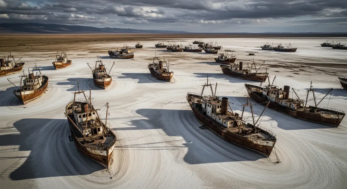
By 1987, the Aral Sea had shrunk to roughly half its original area and lost approximately 60% of its volume. By 1997, it had split into two disconnected water bodies. By 2014, NASA satellites photographed the eastern basin of the former southern sea completely dry — 26,000 square kilometres of exposed salt flat where water had existed uninterrupted for millions of years. The Soviet cotton economy had produced approximately 25 million tonnes of cotton over forty years at a cost of approximately 1,000 cubic kilometres of lake water, an inland fishery that had once yielded 40,000 tonnes of fish annually, and an ecosystem that had maintained a regional microclimate buffering the surrounding steppe agriculture from temperature extremes. The same calculation — treating groundwater and surface water as free inputs to agricultural production rather than finite capital — is now playing out at larger scales in the United States, India, China, and the Arabian Peninsula.
Drawing Down the Account#
The Ogallala's Arithmetic#
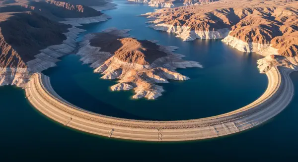
Beneath the High Plains of the United States — spanning parts of eight states from South Dakota to Texas and covering approximately 450,000 square kilometres — lies the Ogallala Aquifer, the world's second-largest known groundwater deposit. Its water content, accumulated over the past 6–25 million years from mountain runoffs and ancient rainfall, is estimated at approximately 3,600 km³ — roughly equivalent to the volume of Lake Huron. The High Plains agriculture it supports produces approximately 30% of all groundwater-irrigated crop value in the United States, with the region accounting for significant portions of US corn, cotton, sorghum, and winter wheat production.
The natural recharge rate of the Ogallala — the rate at which precipitation percolates through the overlying caliche layers to replenish the saturated zone — is approximately 0.1–0.3 km³/yr across the full aquifer system. Annual depletion from irrigation pumping averaged approximately 16–26 km³/yr between 2000 and 2020 in peak demand periods. Applying the Soil Capital Depletion Rate analogy to groundwater: the Ogallala depletion-to-recharge ratio is approximately 80–260:1. We are withdrawing water 80 to 260 times faster than nature replaces it.
Hydrology surveys conducted by the Kansas Geological Survey and the USGS have mapped the consequences in granular detail. In the southern High Plains — the Texas and New Mexico portions of the aquifer — water table declines since European agricultural settlement have reached 30–60 metres in significant portions. In portions of Texas's Llano Estacado, the saturated thickness of the aquifer has declined from 30–50 metres in 1950 to 2–10 metres in recent surveys. When saturated thickness falls below approximately 3 metres, pump-based irrigation is no longer economically viable: the diminution in yield does not cover the increased energy cost of lifting water from greater depth. These counties are not facing a distant future crisis — they are in an active transition away from irrigated agriculture back to dryland farming, with an expected 35–50% reduction in irrigated cropland in the region over the next two decades as the economic aquifer approaches depletion.
The Saudi Fossil Water Sprint#
Saudi Arabia's agricultural expansion in the 1980s and 1990s used fossil groundwater from the Saq Aquifer — a Cambrian sandstone formation with water estimated to be between 20,000 and 30,000 years old — to produce wheat in a country with no significant renewable water source. Between 1980 and 1992, Saudi Arabia became a net exporter of wheat, exporting more than 4 million tonnes in peak years. The production was entirely fossil-water irrigated: there was no recharge, no renewable supply, no sustainable flow rate. The aquifer was a fixed stock and Saudi agriculture was drawing cheques against it.
By the mid-2000s, Saudi Arabia's Ministry of Agriculture recognised that the programme was consuming a non-renewable resource in a country with essentially zero precipitation, and began phasing out domestic wheat production. By 2016, domestic wheat production had been eliminated. The strategy pivoted to land acquisition in sub-Saharan Africa and Southeast Asia — purchasing agricultural land in Ethiopia, Sudan, Pakistan, and elsewhere to produce food abroad for import, effectively externalising Saudi Arabia's virtual water demand to countries with renewable water sources. This strategy has been sharply controversial on land-governance and sovereignty grounds, but its water logic is impeccable: it is precisely the virtual water import mechanism that Tony Allan described in 1993, implemented deliberately as national agricultural policy.
The Saudi case illustrates the asymmetric ecology of fossil water: once consumed, it cannot be replaced on any human timescale. The approximately 300–400 km³ of water extracted from the Saq Aquifer during Saudi Arabia's wheat production era will not recharge within any planning horizon relevant to human civilisation. A resource that took 25,000 years to accumulate was spent in approximately 30 years to produce a commodity — wheat — that is globally traded, storable, and cheaply imported. The WPG for this production was irrelevant because the water was free: the price of fossil groundwater in Saudi Arabia during the wheat programme was the marginal cost of electricity to pump it, with no resource depletion component, no externality for the loss of a non-renewable asset.
India's Invisible Aquifer Crisis#
India is the world's largest groundwater user, extracting approximately 250 km³/yr from its aquifer systems — approximately 25% of global groundwater extraction — to support roughly 60% of its irrigated agriculture and 85% of its rural water supply. The GRACE satellite gravity mission, operated by NASA and the German Aerospace Center, detected the signature of groundwater depletion in GRACE ground mass anomaly data from 2002 onward. Between 2002 and 2016, GRACE observed a net loss of approximately 122 km³ from northern India's aquifer systems — covering Punjab, Haryana, and Rajasthan — equivalent to approximately three times the volume of Lake Geneva.
The distribution of depletion maps almost exactly onto the geography of India's Green Revolution agricultural intensification. Punjab and Haryana — the states that received the highest concentrations of high-yielding variety wheat and rice seeds, subsidised fertiliser, and canal irrigation expansion from the 1960s onward — are the states showing the most severe aquifer depletion. The Green Revolution's productivity gains were real and genuine: wheat yields increased from approximately 0.8 tonnes/hectare in 1960 to approximately 3.2 tonnes/hectare by 1990, substantially improving food security for a population that had experienced severe famines in the mid-twentieth century. But the Revolution's water productivity calculus was left unexamined. The Punjab model of flooded rice-wheat rotation — adopted in a state whose natural ecology is semi-arid, not suited to flooded paddy — required approximately 1.0–1.5m of applied water per season above precipitation, entirely from groundwater. The WPG for Punjabi flooded rice is approximately 5–8 versus drip-assisted or aerobic rice cultivation: the water investment per calorie is 5–8× what optimised technology achieves.
The Pattern and Its Implication#
The Aral Sea, the Ogallala, the Saq Aquifer, and the Punjab groundwater depression share a common structure: large-scale, technically sophisticated agricultural systems were built on water accounting that treated the stock as a free input, ignored the depletion-to-recharge ratio, and deferred the accounting to future populations who would inherit the depleted asset. The irrigation systems themselves were impressive engineering achievements. It was not the engineering that failed — it was the bookkeeping. An economy that generates GDP by spending down a finite resource without booking the asset depletion is not generating wealth; it is liquidating capital and recording the proceeds as income. The WPG, applied systematically with water priced at its true scarcity value, would have restructured the incentives at each of these sites before the aquifer or the lake was gone. The tragedy of the commons is not that the commons was used — it is that it was used without any ledger. The next post examines what a closed ledger would show: the water embedded in every kilogram of food, the dietary choices that either widen or close the gap, and the engineering that makes WPG improvement achievable at commercial scale.