The Day the Sky Went Dark at Noon#
April 14, 1935. Pampa, Texas. A photographer named Arthur Rothstein had been dispatched by Roy Stryker of the Farm Security Administration to document the agricultural crisis of the Southern Plains. At approximately 4:00 PM on that Sunday afternoon, Rothstein looked north and saw a wall of darkness advancing across the horizon. Within minutes, visibility dropped to zero. His exposure meter read zero. He photographed by instinct, producing images that would define the visual history of American agricultural catastrophe: a farmer and his two sons running toward a small wooden building before a dust cloud that towered nearly two kilometres into the sky.
The dust storm of April 14, 1935 — Black Sunday — generated the largest single-day soil loss event in recorded American history. Witnesses reported daylight blocked across an area from Texas to the Dakotas. Dust was deposited in Chicago two days later. Ships 500 kilometres offshore reported red dust on their decks. The storm moved approximately 300 million tonnes of topsoil in a single event — the biological and geological capital accumulated over several thousand years of Great Plains grassland ecology, mobilised in an afternoon.
The Dust Bowl that produced Black Sunday was not a natural disaster. It was an accounting failure — the inevitable consequence of breaking a closed ecological system that had maintained SCDR near 1.0 for millennia and replacing it with an open system that spent the soil capital at SCDR values of 50–500 for fifteen years.
The Making of a Man-Made Disaster#
The Ploughing Decision#
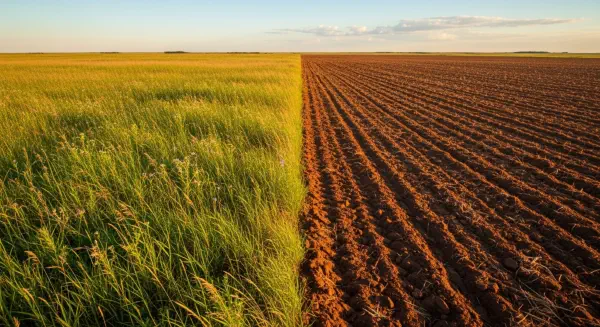
The Southern Plains ecology before European agricultural settlement was a closely coupled system. The dominant vegetation — short-grass and mid-grass prairie — was adapted to the region's semi-arid climate: approximately 350–500mm of rain per year, highly variable from year to year, falling primarily in spring and summer with severe droughts of one to five years occurring every twenty to thirty years. The grasses' root systems — extending 1.5 to 3 metres deep in some species — bound the topsoil against wind erosion. The periodic droughts that would, under a bare-soil agricultural system, generate catastrophic deflation, barely disturbed the prairie's surface because the grass's root mat held it in place. The biological system had self-organised over 10,000 years to operate with SCDR near 1.0 under the climatological variability that characterised the region.
The displacement of this system by deep ploughing began gradually in the 1880s as homesteaders arrived under the Homestead Act and expanded dramatically during World War I and the inflationary wheat prices of the 1910s. Between 1900 and 1930, approximately 40 million hectares of southern plains grassland were ploughed for wheat, cotton, and other row crops — more than 50% of the region's entire grassland. The ploughing severed the root mat that bound the topsoil to the subsoil. Summer fallowing — leaving ploughed fields bare through summer to conserve winter soil moisture — maximised the exposure of bare topsoil to spring and summer winds. The combination was precisely the wrong set of practices for a semi-arid, windy, drought-prone climate system.
The immediate agricultural economics were compelling: wheat prices averaged approximately $2/bushel during the war period, and the mechanical capabilities of the new gasoline tractors allowed a single farmer to plough 40–60 hectares in conditions where horse-drawn equipment had managed 4–8. The externality — the SCDR of the newly ploughed soil — was not priced into the wheat or reflected in land values. The individual farmer's rational decision (plough more land, plant more wheat, earn from the high-yield years) was collectively destructive at the scale of the plains ecosystem.
The SCDR of 1930–1939#
The drought that began in 1931 and intensified through 1934–1935 was a natural climatic event within the normal variability range for the Southern Plains. Tree ring records indicate droughts of similar or greater intensity had occurred approximately every 20–50 years through the preceding several centuries without catastrophic ecological disruption, because the grassland root mat had maintained a soil surface resistant to eolian deflation even when topsoil was dry. After two decades of ploughing, the root mat was gone. The same drought, applied to bare ploughed fields, produced abrasion and deflation at scales that had no prior analogue.
Estimates by the Soil Conservation Service (SCS), established by Hugh Hammond Bennett in 1935 specifically in response to the crisis, calculated that approximately 100 million hectares (one-quarter of the continental United States) were affected by wind erosion at some point during the 1930s Dust Bowl period. Approximately 8 million hectares suffered severe erosion losses of more than 25 centimetres of topsoil depth — equivalent to 12,500 years of topsoil formation at standard semi-arid rates consumed in under a decade. The SCDR for these severely affected areas during peak erosion years was approximately 300–500.
The human consequences were recorded by Rothstein, Dorothea Lange, Walker Evans, and John Steinbeck, whose 1939 novel The Grapes of Wrath traced the westward migration of Dust Bowl refugee families — approximately 500,000 people displaced from the Southern Plains between 1935 and 1940, the largest internal migration in American history to that point. The ecological consequence was a transformation of the region's soil capital that took until the 1990s — and the establishment of the Conservation Reserve Program, which paid farmers to retire highly erodible land from production — to partially reverse.
The Pattern Repeating at Scale#
The Loess Plateau and North China's Soil Crisis#
The Chinese Loess Plateau — a region of approximately 640,000 km² in northwestern China, covering portions of Gansu, Qinghai, Shanxi, Shaanxi, and the Inner Mongolia Autonomous Region — contains the deepest loess (wind-blown silt) deposits on Earth, reaching 100–200 metres in thickness in some areas. The loess was deposited since the Pleistocene by winds carrying fine particles from Central Asian deserts; it is fine-structured, highly productive when moist, and extremely susceptible to water and gully erosion when the vegetation cover is removed.
Traditional terrace agriculture on the Loess Plateau maintained SCDR values of approximately 10–20 on cultivated slopes — high but manageable given the depth of the loess deposit. The intensification of cultivation during the twentieth century, combined with the clearing of upland forests and grasslands for agriculture during the collectivisation period of the 1950s–1970s, raised SCDR values on severely affected slopes to 50–150. The Yellow River — which drains the Loess Plateau — carried approximately 1.6 billion tonnes of sediment per year during peak erosion periods, giving it the highest sediment load of any major river on Earth. The silt deposition downstream in the Yellow River's lower reaches contributed to the progressive raising of the riverbed that has made the Yellow River flood-prone for centuries: the riverbed in the Henan Province now sits 2–10 metres above the surrounding floodplain, contained only by artificial dykes.
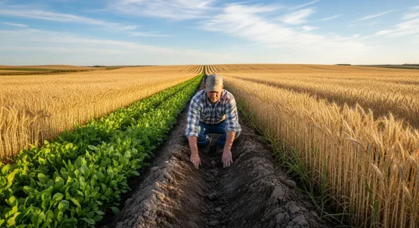
China's Grain for Green (Sloping Land Conversion Programme), initiated in 1999, reversed the conversion incentives: farmers received grain subsidies and cash payments to convert steeply sloping cultivated land back to grass or forest. By 2013, approximately 9 million hectares had been converted. Satellite analysis of NDVI (Normalised Difference Vegetation Index) data from the Loess Plateau showed measurable greening from 2000 onward, and USGS estimates of Yellow River sediment load dropped from approximately 1.5–2.0 billion tonnes/yr in the 1990s to approximately 0.5–0.8 billion tonnes/yr by the 2010s — a 50–60% reduction in just over a decade under sustained vegetation restoration.
The Loess Plateau intervention is the most striking large-scale SCDR improvement in recorded history — not from soil formation (the underlying geological stock is deep enough to absorb centuries of depletion) but from vegetation management that reduced erosion rates dramatically. It demonstrates, on a scale of millions of hectares, that SCDR can be brought from 50–100 toward 5–10 through deliberate land management, and from 5–10 toward 1–2 through intensive restoration. The cost was substantial — the Grain for Green programme spent approximately CNY 105 billion ($15 billion equivalent) over its first decade — but the alternative, the Yellow River dyke maintenance and downstream flood management required to manage a chronically silt-loaded river, was similarly expensive and permanently ongoing. The next post examines what lives in the soil worth protecting as much as the soil itself.