The Wall That Symbolised an Ending#
On November 9, 1989, the Berlin Wall fell. Eleven feet of reinforced concrete, 96 miles through a divided city, 302 watchtowers, tripwires, and a death strip that had killed at least 140 people trying to cross it — all of it came apart overnight in the hands of crowds with sledgehammers and bare hands. When East Germans poured through the Brandenburg Gate, it seemed like more than one specific wall coming down. It seemed like the age’s defining argument about walls — that they were wrong, and that openness would win — had been finally settled.
It had not. In 1989, approximately 15 border barriers existed worldwide. By 2016, when Tim Marshall published Divided, that number exceeded 65. By 2026, it surpasses 70. The European Union — the political project most explicitly constructed on the promise of open internal borders — now has more miles of fencing on its external and internal frontiers than the Iron Curtain maintained at its peak during the Cold War. The decade of openness that followed 1989 was, in historical perspective, an interlude. The age of walls was not ending. It was pausing.
The Invoice for a Century of Lines#
The wall-building epidemic of the 21st century is not a new crisis. It is a compounding invoice — arriving with interest, in instalments — for a century of cartographic violence. The walls being constructed today are not being built where borders were well-designed. They are being built at precisely the fault lines that colonial partition created and that generations of geopolitical inertia left unresolved.
The argument of this series arrives at its synthesis here. Part 1 established that geography writes rules for political order. Parts 2, 3, and 4 documented how colonial powers broke those rules systematically in Africa, the Middle East, and South Asia. This final post traces how the fractures those broken rules created have produced the defining political compulsion of the 21st century: the imperative to wall off what colonialism failed to contain.
The Data Behind the Fences#
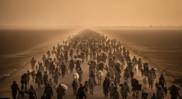
Marshall’s Divided provides a precise account of the wall-building surge. At least 65 countries had constructed border barriers by the mid-2010s, with half of those barriers erected between 2000 and 2016 — in other words, the acceleration was dramatic, concentrated in the first two decades after the post-Cold War opening of borders exposed the demographic pressures that closed borders had previously concealed. By 2026, the United Nations High Commissioner for Refugees estimates more than 122 million people are forcibly displaced worldwide, a number that has more than doubled since 2012. The correlation between displaced populations and new border fortifications is not accidental. It is mechanical.
Europe’s experience is the most illustrative case study. The Schengen Agreement of 1985 created the world’s largest borderless zone, eventually encompassing 27 countries and 420 million people. It seemed to make geographic barriers within a prosperous, integrated bloc permanently obsolete. But Schengen assumed stable, well-governed neighbourhoods. When the Middle East and North Africa — regions whose modern state structures were designed by the very European powers now building fences — began generating unprecedented refugee flows in the 2010s, Schengen’s foundational assumption collapsed. Hungary completed a fence on its Serbian border in September 2015 in a matter of weeks. Austria fortified its Slovenian crossing. North Macedonia built barriers on the Greek border. Sweden reinstated border controls on the Øresund Bridge from Denmark. Within a decade, Europe had assembled a patchwork of fortifications that traced — with considerable cartographic fidelity — the lines between regions the colonial and post-war order had stabilised and regions it had fractured and abandoned.
Three Types of Walls, One Root Cause#
Marshall identifies several categories of wall in Divided, each apparently distinct in its immediate function but each, on analytical examination, traceable to the same structural root: the imposition of arbitrary boundaries upon geographic and demographic realities that were not consulted when the lines were drawn.
India’s fence along its border with Bangladesh — 2,500 miles of steel posts and wire, one of the world’s longest border barriers, still incomplete as of 2026 — is, on its surface, a response to undocumented migration and cross-border smuggling. On a deeper structural level, it is the physical consequence of the Radcliffe Line dividing Bengal. The population of Bangladesh is predominantly Muslim; West Bengal, the Indian state on the other side of Radcliffe’s partition line, is predominantly Hindu. The fence does not follow a river, a mountain range, or any natural boundary. It follows administrative choices made by a British lawyer in 1947. It is not resolving a problem. It is managing a partition that the geography never required.
The Israeli West Bank barrier — 440 miles of concrete wall and steel fence, still under construction after more than two decades — is simultaneously a documented security measure with a measurable effect on reducing organised violence and a physical demarcation of contested territory. But it also traces, imperfectly and controversially, the contested lines of the British Mandate, the Balfour Declaration, and the series of 20th-century commitments made without geographic logic by an imperial power managing competing promises. The wall exists because the decisions of 1916 to 1948 created a landscape of irreconcilable competing claims that subsequent negotiations have been unable to resolve.
The US-Mexico barrier — over 700 miles of fencing and wall as of 2026, with a permanent political constituency for its extension — is the paradigmatic case of a prosperous country attempting to manage the consequences of geographic economic asymmetry. The wealth differential between the United States and Mexico, a GDP per capita ratio of approximately 5.5:1 in purchasing power parity terms, is itself partly a product of historical decisions: the terms of the 1848 Treaty of Guadalupe Hidalgo, the structural underdevelopment embedded in Mexico’s colonial and post-colonial political economy, and the asymmetric terms of trade agreements that have benefited US capital more than Mexican labour. The border does not separate two natural economic entities. It separates regions of a shared landscape that were politically divided by a 19th-century war and have been economically asymmetric, and therefore migratorily pressured, ever since.
The Psychology of the Wall#
Marshall draws on a persuasive insight from evolutionary psychology in the opening of Divided: the tendency to form tribes and build barriers against the “other” is not a modern pathology. It is the default human response to perceived resource competition or identity threat, observable in communities from the African savannah to the digital platforms of the 21st century. The proto-human confrontation at the watering hole in Kubrick’s 2001: A Space Odyssey — shrieking, territorial, immediately tribal — represents a behaviour pattern that neither modernity nor affluence has eliminated.
Digital media has given this ancient behaviour new velocity and new reach. Social media’s architecture of algorithmic reinforcement creates and sustains in-group solidarity with an efficiency that no physical border ever matched, while simultaneously generating and intensifying out-group hostility. The result is that demographic pressures which might once have been processed gradually through employment markets, neighbourhood change, and cultural negotiation now register as immediate existential crises, amplified in real time by platforms optimised for engagement rather than accuracy.
Every bad border, in a media-saturated world, becomes legible as a crisis within hours of generating visible pressure. The walls that result go up faster, and with less political deliberation, than at any previous point in history. Hungary’s fence was completed within weeks of a political decision taken in a climate of media panic. The emotional logic that demanded it was assembled in days on platforms that Marshall’s framework of digital tribalism anticipates with uncomfortable precision.
The Cartographers Left No Forwarding Address#
The men who drew Africa’s borders, the Middle East’s artificial states, and South Asia’s toxic partitions are long dead. The empires they served have dissolved, their flags lowered in succession from Lagos to Karachi to Nairobi to Singapore between 1947 and 1980. The conference rooms in which the lines were drawn have been repurposed. Most people outside academic history departments could not name the Sykes-Picot Agreement, the Berlin Conference, or Cyril Radcliffe without prompting.
But the lines remain. They remain as the legal templates for states that have never achieved geographic coherence. They remain as the fault lines along which 21st-century conflicts fracture. They remain as the seams along which walls go up, because the alternative — acknowledging the geographic nihilism of colonial cartography and building new frameworks from honest ground — requires a political courage that no generation of leaders has yet found sustainable.
The wall-builders of the 21st century believe, in most cases sincerely, that they are responding to contemporary pressures: terrorism, economic migration, demographic anxiety, the fragility of the social contract in post-industrial democracies. They are not wrong that these pressures are real. They are wrong that walls address them. The pressures are symptoms. The disease is the accumulated consequence of borders drawn without consulting geography, ethnicity, or the communities who would live against them.
Geography was not consulted in Berlin in 1884, in a London townhouse in 1916, in a borrowed Delhi bungalow in 1947, or by two American colonels with a road map in August 1945. It has been charging interest ever since, compounding across every year in which the honest reckoning was deferred. The walls going up today are that interest, arriving at scale.
They will not stop until the underlying debt is acknowledged. Not paid — some debts accumulate too long to be fully settled — but mapped honestly, integrated into frameworks of federalism, autonomy, and shared-resource governance that take the physical world seriously. The first step is understanding what the cartographers of chaos actually did. The second is understanding that it was, at its root, a failure not of morality alone, but of geography.