How colonial borders, designed to carve out spheres of influence, created artificial states and planted the seeds of modern political crises#
When the Bakongo people first learned that they had been divided, it was not through an official proclamation or a treaty ceremony. A hunter following a familiar trail through the forest might encounter a new flagpole, a wooden post painted in the colours of Portugal, or France, or Leopold’s Congo Free State. A trading party crossing the river to buy salt might be told by a man in a blue uniform that they were now entering foreign territory and must pay a tax. The Bakongo, a nation of perhaps two million people, had been split into three separate colonies by lines drawn on a map in a European conference room. Their priests, their markets, their marriage networks, the shrines of their ancestors—all now straddled the frontiers of three different empires. It would take decades for the full implications of that division to become clear, and the consequences are still being reckoned with today. The map of modern Africa is a palimpsest of arbitrary decisions made by men who had never set foot on the continent, and the states they created have struggled ever since to contain the human realities those decisions ignored.
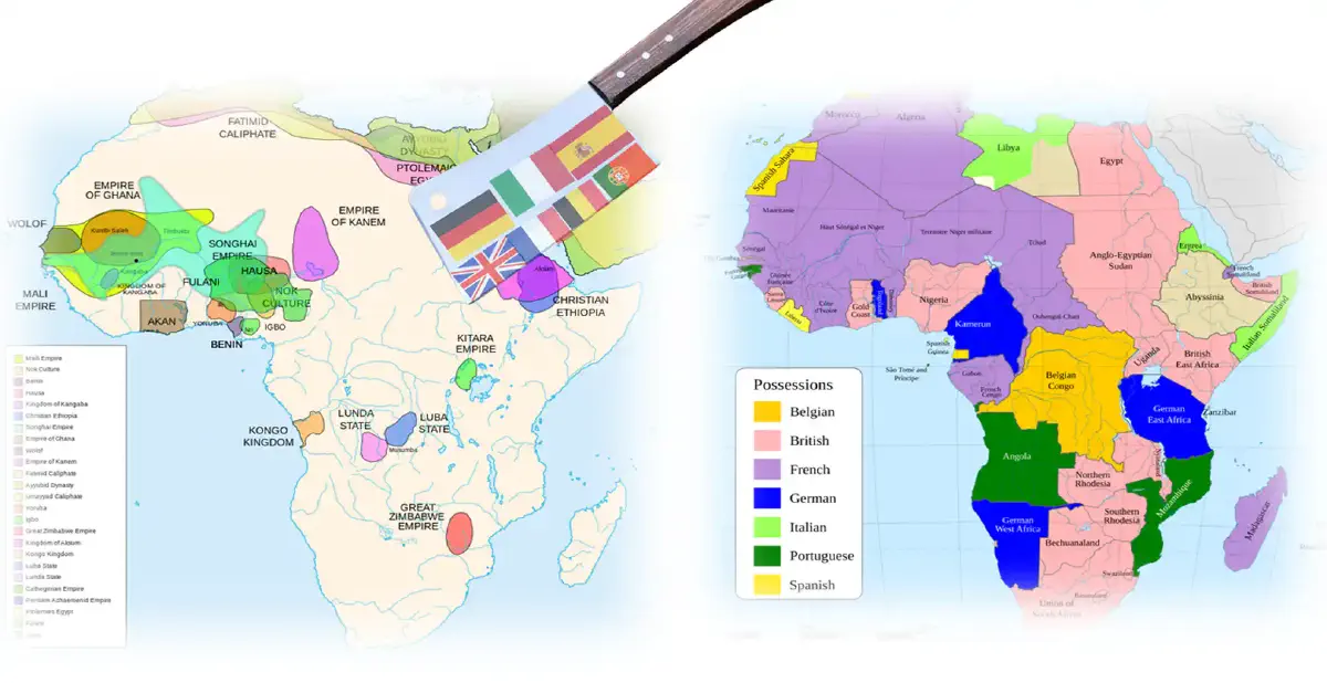
The drawing of colonial borders was not an act of cartographic precision. It was a frantic, competitive, often comical exercise in which the diplomats of Europe carved up a continent in much the same spirit as a syndicate of investors dividing a newly discovered goldfield. The instruments were compasses and rulers. The raw material was blank spaces on a map. The guiding principle was not ethnographic coherence, economic viability, or geographic logic. It was the balance of power among the scrambling imperial states. The result was a jigsaw puzzle of artificial political units, many of them unviable, most of them unstable, all of them imposed by force. The consequences of this division have been among the most persistent and destructive legacies of the colonial era.
The geometry of conquest#
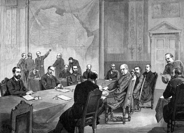
The Berlin West Africa Conference of 1884–85 is often misremembered as the event that partitioned Africa. In fact, it partitioned nothing directly. It established the rules under which partitioning could proceed. The crucial innovation was the doctrine of the hinterland. If a European power established a foothold on the coast—a fort, a trading post, a treaty with a local chief—it could claim jurisdiction over the interior behind that foothold, stretching inland to an unlimited distance, until it encountered another European claim. The doctrine was vague, contradictory, and entirely lacking in legal foundation. Lord Salisbury, perhaps the most cynical of the partition’s architects, observed that it “indicates the uninformed and unstable condition of international law as applied to territorial claims resting on constructive occupation or control.” But it was precisely because the doctrine was vague that it served its purpose. It allowed the powers to make expansive claims on paper, to be adjusted later by bilateral treaties, without the tiresome necessity of actually occupying the territories in question.
The bilateral treaties that followed were hammered out in European chancelleries without a single African representative present. The Anglo-German Agreement of 1886 partitioned the domains of the Sultan of Zanzibar. The Heligoland Treaty of 1890 settled the boundaries of British and German East Africa, handing Uganda to Britain and the North Sea island of Heligoland to Germany, and extinguishing the sovereignty of Zanzibar in the process. The Franco-British Convention of 1898 completed the partition of West Africa, drawing a line from the Niger River to Lake Chad. The Anglo-French Convention of 1899 settled the Egyptian question. None of these agreements paid the slightest regard to the political communities that existed on the ground. They were exercises in great-power diplomacy, conducted in the language of spheres of influence and reciprocal compensation.
When the diplomats’ straight lines were projected onto the ground, the results were often absurd. The border between Egypt and Sudan, drawn at the 22nd parallel, sliced through the grazing lands of the Ababda and Bishari nomads. The boundary between Kenya and Somalia, a straight line running from the Indian Ocean to the Ethiopian frontier, divided the Somali Ogaden clans from their kin. The Congolese-Zambian border, following the watershed of the Congo-Zambezi divide, separated the Lunda and Luvale peoples who had lived in a single political and economic zone for centuries. The General History of Africa estimates that roughly 30 percent of Africa’s total border length consists of straight lines, drawn along parallels and meridians without reference to the topography or the human geography beneath them.

The peoples divided#
The human consequences of these geometric lines were profound and enduring. The Bakongo were split among the French colony of Moyen-Congo, the Belgian Congo, and Portuguese Angola. The same language, the same chiefs, the same marriage customs, the same trading networks—all were now subject to three different legal systems, three different currencies, three different educational policies. The Bakongo of Angola could not visit their relatives in the Belgian Congo without crossing an international frontier. When they did, they were subject to the pass laws and labour regulations of a different colonial administration. The shared rituals of the kingdom of Kongo, a state that had existed for four centuries before the Europeans arrived, became an act of clandestine border-crossing.
The Somali people suffered an even more extreme division. Their traditional grazing lands, which stretched from the Ogaden plateau to the Indian Ocean coast, were carved into five separate territories: British Somaliland, Italian Somaliland, French Somaliland, the Ethiopian province of Ogaden, and the Northern Frontier District of Kenya. The British, French, and Italian administrations each imposed their own legal codes, their own languages of administration, and their own patterns of economic development. The Somalis, who had for centuries been one of the most ethnically homogeneous peoples on the continent, with a single language, a single religion, and a single pastoral culture, found themselves citizens of half a dozen different polities. The dream of a unified Somali nation, which would drive the irredentist politics of the Horn of Africa for the next century, was born of this fragmentation.
The Ewe, a relatively compact people occupying the coastal savanna between the Volta and Mono rivers, were divided between the British Gold Coast and German Togoland, a division that was perpetuated after the First World War when western Togoland became a British mandate and eastern Togoland a French one. The Ewe unification movement, which began in the 1920s and continues in modified form to this day, is a direct product of this arbitrary boundary. The Senufo of the West African savanna were split among three French colonies: Soudan, Ivory Coast, and Upper Volta. The Lunda are divided between Angola, Congo, and Zambia. The Chewa between Malawi, Zambia, and Mozambique. The list is not endless—there are roughly 3,000 ethnic groups in Africa—but it is long enough to have generated a continent-wide pattern of irredentist agitation and cross-border tension that has been one of the most persistent obstacles to post-colonial state-building.
The legacy of the hinterland doctrine#
The process by which the blank spaces on the map were filled in was as arbitrary as the original straight lines. The hinterland doctrine meant that a power with a coastal foothold could claim the interior by sending expeditions to sign treaties with local rulers, or more commonly, to plant flags and establish military posts, before a rival power could do the same. The result was a mad scramble of exploration and occupation, in which speed was valued above accuracy. The boundary commissions that were subsequently dispatched to demarcate the lines on the ground were often working with incomplete maps and conflicting information. They made decisions based on the location of a river that had been misnamed on a German atlas, or a mountain that turned out to be a low hill, or a treaty signed with a chief whose authority extended no further than the next village.
In the Sahel, the line between French West Africa and British Nigeria was settled by the Say-Barruwa Agreement of 1890, which roughly followed the 13th parallel. The agreement was intended to give the British a clear corridor to Lake Chad. It paid no attention to the Sokoto Caliphate, which straddled the new boundary, or to the Kanuri of Borno, whose heartlands were split between the two empires. In the Horn, the border between Ethiopia and British Somaliland was settled by a 1897 treaty between Menelik II and the British, which was so vaguely worded that it remained a source of dispute for the next half century.
The moment of colonial independence in the late 1950s and early 1960s froze these arbitrary arrangements into the structure of the international system. The new African states, acutely conscious of their fragility, accepted the colonial boundaries as inviolable. The Charter of the Organization of African Unity, adopted in 1963, explicitly pledged member states to respect the borders existing at independence. This was a pragmatic decision, taken in the knowledge that any attempt to redraw boundaries along ethnic lines would unleash a cascade of secessionist claims and territorial conflicts that could dissolve the continent into chaos. The principle of uti possidetis—you shall possess what you possessed—was borrowed from the Latin American experience and applied with equal rigidity. It has kept the peace, after a fashion, but it has also perpetuated the structural irrationalities of the colonial division.
The creation of giant and midget states#
The colonial partition did not merely divide peoples. It created political units of wildly disparate size and viability, a legacy that has shaped the economic and strategic landscape of post-colonial Africa in ways that are rarely acknowledged. The French colony of Algeria, with an area of 2.4 million square kilometers, was a giant, as was the Belgian Congo, with 2.3 million. The Anglo-Egyptian Sudan was larger still. At the other end of the scale, the Gambia was a sliver of territory no more than thirty kilometres wide, entirely surrounded by Senegal except for a short Atlantic coastline. Lesotho was an enclave within South Africa, Swaziland a slightly larger neighbour. The disparity was not random. It reflected the peculiarities of European rivalry rather than any African reality. The Gambia existed because the British had established a trading post at the mouth of the Gambia River in the seventeenth century and had stubbornly refused to cede it to the French, who controlled the surrounding territory. Its borders were drawn by the maximum range of a British naval cannon from the riverbank. Swaziland survived as an independent entity because neither Britain nor the Transvaal could agree on which of them should annex it, a stalemate that left the monarchy intact by default.
The economic consequences of these disparities have been severe. Some of the largest states—Sudan, Congo, Angola—have been among the poorest and most conflict-ridden on the continent, their sheer size making effective governance extraordinarily difficult. Some of the smallest—Lesotho, Swaziland, the Gambia—have been economically dependent on larger neighbours to a degree that renders their sovereignty largely theoretical. The landlocked states, another product of the partition, face a permanent geographic handicap. Mali, Niger, Chad, Burkina Faso, Zambia, Zimbabwe, Uganda, Rwanda, Burundi, Malawi: all are cut off from the sea, their access to global markets dependent on the goodwill of their coastal neighbours and the transport infrastructure built by the colonial powers for the export of primary commodities, not for the integration of regional economies. The rail line from Kano to Lagos, from Kampala to Mombasa, from Ouagadougou to Abidjan—these arteries of the colonial economy remain the economic lifelines of the interior, and their vulnerability to political disruption has been a constant source of instability.
The invention of chiefs and the fragmentation of societies#
The artificiality of colonial borders was compounded by the artificiality of the administrative structures imposed within them. In pre-colonial Africa, political authority was often fluid, overlapping, and contested. There were empires and kingdoms, but there were also stateless societies, confederacies of autonomous villages, and systems of authority based on age-grade organizations, secret societies, or religious cults. The colonial administrator, faced with this bewildering variety, needed a single, legible structure through which to govern. He created it. Where a paramount chief existed, he was co-opted, his authority amplified by colonial backing, his traditional checks and balances stripped away. Where no paramount chief existed, one was invented. The "warrant chiefs" of southeastern Nigeria, the "chefs de canton" of French West Africa, the "akidas" and "jumbes" of German East Africa: these were not traditional authorities. They were colonial functionaries, appointed because the administrator needed a local interlocutor who could deliver taxes and labour. Their authority was a product of the colonial state, and it collapsed the moment that state withdrew.
The creation of these artificial hierarchies had profound effects on internal politics. It froze what had been fluid systems of authority into rigid, hereditary structures. It created new arenas of competition, as rival claimants vied for the spoils of colonial preferment. It produced a class of African intermediaries whose interests were tied to the colonial order, and who therefore became targets of popular resentment when that order began to crumble. The depositions of chiefs in the Gold Coast in the inter-war period, the attacks on "colonial chiefs" during the nationalist movements, the struggles over chieftaincy succession that have convulsed so many post-colonial states: all are, in part, consequences of the colonial reinvention of tradition.
The colonial administration also reshaped ethnic identity. The grid of administrative units—provinces, districts, cantons, chiefdoms—did not simply map onto pre-existing ethnic groups; it created new ones. The boundaries of an administrative unit defined who was in and who was out, who had access to land, who was liable for taxation, who could participate in local courts. Over time, these administrative categorizations hardened into ethnic identities. People who had previously identified themselves by lineage, village, or cult affiliation began to identify themselves as members of an ethnic group defined by the colonial district in which they lived. The "tribe" as a fixed, bounded entity was, in many cases, a colonial invention, and its legacy has been the ethnic politics that has bedevilled so many African states since independence.
The negative nationalism of artificial states#
The African nationalism that emerged in the inter-war period and drove the independence movements of the 1950s and 1960s was, in large measure, a product of these artificial boundaries. It was not the nationalism of a pre-existing nation, a unified people with a common language, history, and culture demanding its own state. It was, rather, the nationalism of a colonial territory, a sense of shared identity forged by the common experience of subjection to a particular colonial administration. The General History makes this point with characteristic clarity: nationalism in colonized Africa was "taking a reverse course to the expression of the same phenomenon in Europe. Contrary to what happened in Europe, the state was created before the cultural nations that would make it a meaningful political community were welded together."
This negative nationalism, born of the shared experience of humiliation, exploitation, and resistance, was powerful enough to drive the colonial powers out. It was not always powerful enough to hold the new states together once the common enemy had departed. The Nigerian civil war of 1967–70, the Congolese crisis of the early 1960s, the endless conflicts in the Horn, the chronic instability of the Sahelian states: all are, in part, consequences of the fundamental weakness of territorial nationalism in the face of ethnic, regional, and religious identities that the colonial state had never succeeded in submerging.
The African leaders who took power at independence were acutely aware of this fragility. They inherited states whose boundaries had been drawn by foreigners for foreign purposes, whose populations had no shared history of political community, whose economies were oriented toward the export of a narrow range of primary commodities to Europe, and whose administrative structures were designed for extraction rather than development. They responded, for the most part, by attempting to build national unity through the expansion of the state, the suppression of ethnic politics, the promotion of a single national language, and the cultivation of a nationalist ideology. These efforts have had mixed success. In some cases, they have produced stable, relatively cohesive nation-states. In others, they have produced brutal civil wars, failed states, and the resurgence of identities that the colonial project had attempted to obliterate.
The map that cannot be redrawn#
The borders drawn in the age of the Scramble have proven remarkably durable. The secession of South Sudan in 2011 was the first successful redrawing of a colonial border since the independence era, and it was achieved only after decades of devastating civil war. The secession of Eritrea from Ethiopia in 1993 was another rare exception, and it, too, was paid for in blood. The principle of the inviolability of colonial borders remains a cornerstone of the African state system, not because anyone believes the borders are just or rational, but because the alternative—a continent-wide process of border revision—is too terrifying to contemplate. The map of Africa is a prison from which no one can escape without pulling the walls down on everyone else.
The colonial powers who drew those borders understood, at some level, what they were doing. They were not ignorant of the ethnic complexity of the continent. Their own intelligence reports, compiled by the explorers and missionaries who had mapped the interior, described the linguistic and political geography in considerable detail. The partition was not a product of ignorance; it was a product of indifference. The Africans whose lives were being divided by straight lines had no standing in the competition of the great powers. They were not consulted because they were not considered to exist as political agents. The conference rooms of Berlin and Brussels and Paris were filled with the maps of Africa, but the people who lived on those maps were invisible.
That invisibility has been the most lasting wound of the colonial partition. The modern African state must somehow construct a legitimate political order out of materials that were designed to serve the needs of an extractive empire. It must create a sense of common citizenship among peoples who were bundled together by the accident of competition between rival European powers. It must manage the tensions generated by borders that cut through the middle of ethnic homelands and by economies that were shaped to serve foreign markets. The country that never existed—the coherent, ethnically homogeneous, economically viable nation-state—is a phantom that haunts every post-colonial government. The countries that do exist are the real, imperfect, fragile products of the paper partition, and their struggle to endure is the central political drama of modern Africa.

The enduring weight of history#
The colonial partition, for all its arbitrariness, created a framework that has proven extraordinarily difficult to escape. The fifty-odd states that emerged from the colonial era have become the only political reality that most of their citizens have ever known. The new elites that took power at independence had been socialized within the colonial administrative grid; their careers, their networks, their very identities were products of the territories that the Europeans had delineated. They had no interest in dismantling those territories, any more than the colonial administrators who had trained them. The result has been an African state system in which the territorial integrity of the existing units is treated as sacrosanct, even when those units are manifestly unviable.
The cost of this rigidity has been enormous. The Somali people, divided among five territories, have never reconciled themselves to their fragmentation. The Ogaden war of 1977–78 between Somalia and Ethiopia was a direct result of the colonial division of the Horn. The persistent instability of eastern Congo, with its succession of rebel movements and foreign interventions, is rooted in a colonial border that pays no attention to the ethnic geography of the Great Lakes region. The chronic underdevelopment of the landlocked Sahelian states—Mali, Niger, Burkina Faso, Chad—is a function of their geographic inheritance from the partition, which left them dependent on long, vulnerable corridors to the sea.
Yet the alternative is no better. Any attempt to redraw borders along ethnic lines would require answering the question of which ethnic group gets which territory, a question that can be settled, in the absence of a powerful and impartial arbiter, only by war. The former Yugoslavia provides a sobering example of what can happen when a multi-ethnic state organized around artificial administrative boundaries disintegrates along ethnic lines. Africa, with its vastly greater ethnic complexity, would almost certainly experience an even more catastrophic unraveling. The colonial borders, for all their injustice, are the only borders that exist, and the price of challenging them is almost certain to be higher than the price of enduring them.
The country that never existed—the nation-state that corresponds neatly to a single ethnic group with a single language and a shared history—is not the only kind of political community that can exist. The modern African state, however artificial its origins, can be made to work if it can command the loyalty of its citizens and provide them with security, justice, and a measure of prosperity. The challenge is not to redraw the map but to make the existing map liveable. The partition of Africa was an act of violence, executed for the benefit of outsiders. The construction of a just and durable political order on the foundations that the partition laid is the unfinished business of African independence. It will take generations to complete, and it may never be completed at all. But it is the only work that matters. The mapmakers who drew the straight lines are long dead, but the lines remain, and the people who must live within them have no choice but to try to make them into something better than they were ever intended to be.